


Where did you ride in Southern California today?
 01-09-21, 03:09 AM
#751
velo-dilettante
Thread Starter
Join Date: Apr 2009
Location: insane diego, california
Posts: 8,536
Bikes: 85 pinarello treviso steel, 95 battaglin steel, 95 look kg 131 carbon, 11 trek madone 5.2 carbon
Liked 3,385 Times
in
1,798 Posts
you go because de luz area can get confusing. enjoy the challenge.
ps...if you get on a dirt part of what you think is de luz rd, it will stay dirt for a long time. better to turn around and seek pavement
unless you want an adventure and/or are rocking big tires.
pps...mission rd from fallbrook to the 15 fwy carries a lot of traffic but has decent shoulders on both sides.
i'd feel better staging (on either end) from temecula old town area or dtown fallbrook tho vs somewhere off the 15 fwy.
look forward to your write-up!
Last edited by diphthong; 01-09-21 at 03:20 AM.
 01-09-21, 04:45 PM
#752
Senior Member
Thanks for the info and tips, as always. Unfortunately, I got fatally delayed this morning, but hope to do it tomorrow instead. Good to know about de luz dirt.
Do you have any recommendations for extending the ride a bit? Carananchos / Los Gatos to the top looks attractive on google maps and I see it gets decent use on the Strava heatmap.
What do you recommend for (speaking of a completely different trip) Highland Valley? Just out and back?
Do you have any recommendations for extending the ride a bit? Carananchos / Los Gatos to the top looks attractive on google maps and I see it gets decent use on the Strava heatmap.
What do you recommend for (speaking of a completely different trip) Highland Valley? Just out and back?
01-09-21, 08:04 PM
#753
velo-dilettante
Thread Starter
Join Date: Apr 2009
Location: insane diego, california
Posts: 8,536
Bikes: 85 pinarello treviso steel, 95 battaglin steel, 95 look kg 131 carbon, 11 trek madone 5.2 carbon
Liked 3,385 Times
in
1,798 Posts
Thanks for the info and tips, as always. Unfortunately, I got fatally delayed this morning, but hope to do it tomorrow instead. Good to know about de luz dirt.
Do you have any recommendations for extending the ride a bit? Carananchos / Los Gatos to the top looks attractive on google maps and I see it gets decent use on the Strava heatmap.
What do you recommend for (speaking of a completely different trip) Highland Valley? Just out and back?
Do you have any recommendations for extending the ride a bit? Carananchos / Los Gatos to the top looks attractive on google maps and I see it gets decent use on the Strava heatmap.
What do you recommend for (speaking of a completely different trip) Highland Valley? Just out and back?
de luz is a very confusing road from the north/temecula end and only slightly confusing from the south/fallbrook end.
from the north-rancho california rd. out of temecula old town area-you get to the top (avenida de oro appears first and it descends from
rancho california rd to quickly-.25 mile-connect you to sandia creek rd. if desired) and rancho california rd. turns into de luz rd.
the road changes name to de luz murrieta rd. for a spell for some reason (?!?!) and then becomes de luz rd. again and joins up
with sandia creek rd. about 1.5 miles north of town fallbrook.
from the south and that de luz/sandia creek intersection, you make a left onto de luz rd. and wind around up and down for a while
and then the road forks in a low spot near a canopy. the left fork turns immediately into dirt while the right stays paved. i recommend the paved part the first time for sure. eventually, the road turns into rancho california rd. and you gain the ridge and can see temecula/murrieta and beyond. before you hit the big "s" curve heading downhill, that avenida de oro quickie turnoff to sandia creek rd. (if doing a loop) is right there.
the sandia creek/de luz loop-about 35 miles from either fallbrook or temecula-is already a handful. anything other than that in the de luz area is guaranteed to really test you. there are some really steep grades within the area and los gatos is one of the toughest semi-short climbs in all of socal. extending the ride, there are a couple of adjacent options:
the rainbow/reche/fallbrook area you spoke of.
toodling around the temecula wine country.
heading north from the base of rancho california rd/temecula on jefferson ave. (until the very end) and hanging a left on clinton keith rd. climb clinton keith rd. heading west and follow the road as it gently curves southwards around the santa rosa plateau preserve at the top as things flatten out. it's a really pretty area-esp in spring or after it rains with all the greenery and vernal pools. the gently rolling hills and huge oak trees recall a california 150 years ago. traffic is generally chill here. some nice views of palomar mtn, the san jacintos and the san berdoos if it's clear. road turns into via volcano for approx a mile before continuing southwards and doglegging onto the top of los gatos rd. make sure your brakes are working cause you're gonna need 'em. after that vertiginous descent to carancho, i'd hang a left at the bottom/stop sign. a right turns into dirt(y) de luz rd. and going straight leads you onto the mother of all natural roller-coasters. the left will take to back to paved de luz rd.

santa rosa plateau

santa rosa plateau

sandia creek rd.
sandia creek rd.

sandia creek rd.
Last edited by diphthong; 01-09-21 at 08:14 PM.
01-09-21, 08:23 PM
#754
velo-dilettante
Thread Starter
Join Date: Apr 2009
Location: insane diego, california
Posts: 8,536
Bikes: 85 pinarello treviso steel, 95 battaglin steel, 95 look kg 131 carbon, 11 trek madone 5.2 carbon
Liked 3,385 Times
in
1,798 Posts
Thanks for the info and tips, as always. Unfortunately, I got fatally delayed this morning, but hope to do it tomorrow instead. Good to know about de luz dirt.
Do you have any recommendations for extending the ride a bit? Carananchos / Los Gatos to the top looks attractive on google maps and I see it gets decent use on the Strava heatmap.
What do you recommend for (speaking of a completely different trip) Highland Valley? Just out and back?
Do you have any recommendations for extending the ride a bit? Carananchos / Los Gatos to the top looks attractive on google maps and I see it gets decent use on the Strava heatmap.
What do you recommend for (speaking of a completely different trip) Highland Valley? Just out and back?
highland valley is a stiff climb heading west to east.
could also do the del dios/harmony grove/san elijo hills/double peak area just west of the 15 fwy and south of the 78 fwy.
or the west lilac/couser canyon/rice canyon corridor just east of the 15 fwy and north of valley center.
or the rancho santa fe area in between the 5 and 15 fwys,
Last edited by diphthong; 01-09-21 at 08:27 PM.
Likes For diphthong:
01-09-21, 09:35 PM
#755
Senior Member
Gorgeous photos! And thanks as always, for all the info. I hope to buy you a few drinks sometime! Thanks again!
The mother of all roller coasters? That sounds intriguing. But I think for another time! The plateau sounds gorgeous though. Tomorrow's supposed to be an easy day, but maybe I'll feel inspired to jump over from the De Luz loop. [Edit: Wow! Just look at the grade from De Luz up Los Gatos. 20+% for lots of it!]
One thing I've been thinking about lately. Since I grew up here in the 80s and 90s, San Diego has developed so much. How much longer until its all suburbs all the time?
Last edited by btppberk; 01-09-21 at 09:39 PM.
01-09-21, 10:18 PM
#756
velo-dilettante
Thread Starter
Join Date: Apr 2009
Location: insane diego, california
Posts: 8,536
Bikes: 85 pinarello treviso steel, 95 battaglin steel, 95 look kg 131 carbon, 11 trek madone 5.2 carbon
Liked 3,385 Times
in
1,798 Posts
Gorgeous photos! And thanks as always, for all the info. I hope to buy you a few drinks sometime! Thanks again!
The mother of all roller coasters? That sounds intriguing. But I think for another time! The plateau sounds gorgeous though. Tomorrow's supposed to be an easy day, but maybe I'll feel inspired to jump over from the De Luz loop. [Edit: Wow! Just look at the grade from De Luz up Los Gatos. 20+% for lots of it!]
One thing I've been thinking about lately. Since I grew up here in the 80s and 90s, San Diego has developed so much. How much longer until its all suburbs all the time?
The mother of all roller coasters? That sounds intriguing. But I think for another time! The plateau sounds gorgeous though. Tomorrow's supposed to be an easy day, but maybe I'll feel inspired to jump over from the De Luz loop. [Edit: Wow! Just look at the grade from De Luz up Los Gatos. 20+% for lots of it!]
One thing I've been thinking about lately. Since I grew up here in the 80s and 90s, San Diego has developed so much. How much longer until its all suburbs all the time?
since san diego is surrounded on all sides (pacific ocean, camp pendleton, cleveland national forest, mexico), there's only so much suburbia that can take hold.
instead of the la/phoenix/san jose/sacramento/las vegas giant basins, we've got smaller little corridors or pockets that can be converted. biggest, unconverted suburbia-potential area close to town sd that comes to mind in ramona. lots of flat area with lots of farms. mom/dad pass away...do the kids want to cash in?
seem to remember there being some attempt to shoehorn a large development into the west lilac rd area nw of valley center and east of the 15 fwy a few years ago but pretty sure it got voted down. there is still the proposal to move/expand the sd intl airport and put it out in boulevard, about an hour east off the 8 fwy. they'd need to build bullet trains but there is plenty of land out there and if they did build a viable international airport out there, the houses, et al, would follow.
Last edited by diphthong; 01-10-21 at 01:32 PM.
Likes For diphthong:
01-11-21, 01:54 AM
#757
Senior Member
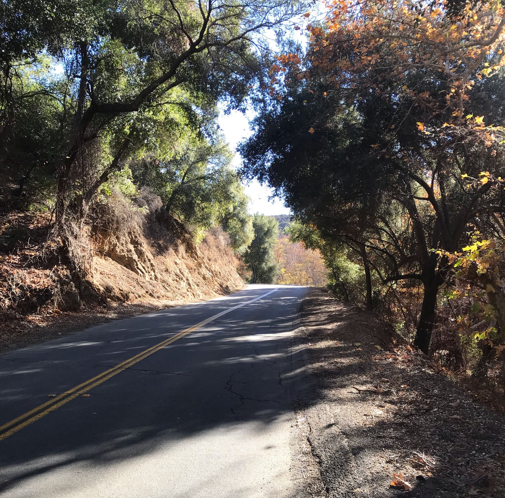
Followed ooga-booga's always excellent tips for De Luz and Sadia Creek. Started in Temecula office park near the bottom: a ton of street parking. Went down Sadia Creek Road. Had not looked at the climbing profile before going: be warned its lots of roller-coaster up and downs. Nothing too onerous (though there's one downhill I'd hate to come up -- its short but very steep), but I found I was often in the wrong gear at the wrong moment. Good practice. There's a small detour on Sadia Creek. Didn't see much traffic. There was even less on De Luz. Lots more on Rancho California--and was out there late, after dark: not fun.
Overall this was a great ride! One of my favorite ones that I've done in San Diego, up there with Mesa Grande and Kitchen Creek. The typography of the De Luz is surprising varied. Sadia Creek is a bit more up and down; De Luz a bit more gentle. The scenery was excellent: Sadia more small farms, De Luz less developed. Lots of beautiful Oaks throughout--reminded me of NorCal riding.
Thanks for the tips Ooga-Booga! Much appreciated!
Likes For btppberk:
01-11-21, 01:57 AM
#758
Senior Member
Southbound on Sadia
Likes For btppberk:
01-11-21, 03:42 AM
#759
velo-dilettante
Thread Starter
Join Date: Apr 2009
Location: insane diego, california
Posts: 8,536
Bikes: 85 pinarello treviso steel, 95 battaglin steel, 95 look kg 131 carbon, 11 trek madone 5.2 carbon
Liked 3,385 Times
in
1,798 Posts
glad you tackled it. de luz area is an outlier in socal riding. the navigation is difficult. it's an insular area with great views but they're usually short-less than 3 miles.
the nearly constant up and down. the intimacy and lack of ftraffic. no support. minimal cell service. not too far but not too close either. maybe the last socal
shangri-la...
yeah...that grade you descended on sandia creek rd. is an absolute bear heading uphill. the grade you climbed on the other side is about 25% as difficult
and it's not a pushover.
Last edited by diphthong; 01-11-21 at 03:46 AM.
Likes For diphthong:
01-11-21, 06:09 PM
#760
Senior Member
Join Date: Aug 2012
Location: Los Alamitos, Calif.
Posts: 2,523
Bikes: Canyon Endurace
Liked 975 Times
in
566 Posts
So fart this month I'm at about 109 miles. No spectacular rides, just getting back in the saddle after my accident in July. I'm finally comfortable riding again and as long as this nice weather holds up this might be the biggest mileage January I've ever had. Tomorrow will be a 30 R/T up the SGRT from El Dorado Park. I'm finally back to being able to accomplish 30 miles and hope to be at 50 before the month is out.
01-11-21, 09:35 PM
#761
Senior Member
glad you tackled it. de luz area is an outlier in socal riding. the navigation is difficult. it's an insular area with great views but they're usually short-less than 3 miles.
the nearly constant up and down. the intimacy and lack of ftraffic. no support. minimal cell service. not too far but not too close either. maybe the last socal
shangri-la...
yeah...that grade you descended on sandia creek rd. is an absolute bear heading uphill. the grade you climbed on the other side is about 25% as difficult
and it's not a pushover.
the nearly constant up and down. the intimacy and lack of ftraffic. no support. minimal cell service. not too far but not too close either. maybe the last socal
shangri-la...
yeah...that grade you descended on sandia creek rd. is an absolute bear heading uphill. the grade you climbed on the other side is about 25% as difficult
and it's not a pushover.
Likes For btppberk:
01-11-21, 10:12 PM
#762
velo-dilettante
Thread Starter
Join Date: Apr 2009
Location: insane diego, california
Posts: 8,536
Bikes: 85 pinarello treviso steel, 95 battaglin steel, 95 look kg 131 carbon, 11 trek madone 5.2 carbon
Liked 3,385 Times
in
1,798 Posts
or roll through to fallbrook/temecula, it's a def time saver.
always seems to take forever to get from temecula to clinton keith rd. via (mostly) jefferson ave. it's the most direct way but the lights always seem
to conspire against me. if you wanna do another 35-45 mile ride in the area, you can park near the base of clinton keith/palomar st and ride up
clinton keith, drop down los gatos to sample de luz, descend rancho california rd, and hang a left on jefferson back to the start...or you can ride north
to the 74 next to lake elsinore and ascend that to the summit, drop down a spell to the little store for a bevvie/munchie and then turn around and
descend back to the valley. fun ascent/descent on that stretch of the 74 and nice views in the winter with the snowcapped peaks right there.
in the warmer months-may to october-the views are pretty hazy.
01-12-21, 02:22 AM
#763
Senior Member
yah...can't recommend the los gatos ascent or descent because it's so damned steep. it's a handy descent tho, if you're looking to nibble at de luz
or roll through to fallbrook/temecula, it's a def time saver.
always seems to take forever to get from temecula to clinton keith rd. via (mostly) jefferson ave. it's the most direct way but the lights always seem
to conspire against me. if you wanna do another 35-45 mile ride in the area, you can park near the base of clinton keith/palomar st and ride up
clinton keith, drop down los gatos to sample de luz, descend rancho california rd, and hang a left on jefferson back to the start...or you can ride north
to the 74 next to lake elsinore and ascend that to the summit, drop down a spell to the little store for a bevvie/munchie and then turn around and
descend back to the valley. fun ascent/descent on that stretch of the 74 and nice views in the winter with the snowcapped peaks right there.
in the warmer months-may to october-the views are pretty hazy.
Interesting about 74. It looks so narrow on google street view...
Have any picks for this Friday or Saturday? Looking pretty nice in the East County. Low 70s in Julian, high 70s (!) in Santa Ysabel, 69 on Palomar. Thinking maybe Mesa Grande and Palomar East Grade. Apropos of the recent tragedy, should one stay off of 79 and Sunset Highway on weekends?
01-12-21, 08:02 PM
#764
velo-dilettante
Thread Starter
Join Date: Apr 2009
Location: insane diego, california
Posts: 8,536
Bikes: 85 pinarello treviso steel, 95 battaglin steel, 95 look kg 131 carbon, 11 trek madone 5.2 carbon
Liked 3,385 Times
in
1,798 Posts
so went to lake elsinore and did the climb of ca hwy 74 up to the summit (5 mile climb) and descended
to the 74 candy store (closed). turned around there (9 miles in) and headed back. hung a right on
south main divide rd. about a third of a mile before the summit and took that to about 1.5 miles past
elsinore peak (ton of communication towers clustered on top). south main divide rd which was
paved for the stretch i rode it and looked to be paved for at least another mile on its descent towards the
clinton keith rd. corridor. will hafta investigate more. super low traffic and some nice views of local mtn ranges
and the lake. turned around and descended the 74 back to the start. low 70's to start but clouds rolled in around
2:15pm so broke out the windbreaker for the 74 descent. pavement quality on 74 and south main divide rd.
generally 7-8/10. some brand new stretches on the 74. on again/off again shoulder for the 5 mile
ascent/descent from/to lake elsinore plus some turnouts. fewer turnout once west of the summit.
little support market about a half mile west of the summit along with a roadside grill that (was closed)
looks like it could possibly be open on the weekends (with the whatever goes these days with resto operators
vs the covid mandates). public usfs unisex ba�o (tp, no seat covers) plus water spigot outside nearby just after the turnoff onto south main divide rd. on the left by the california firefighter memorial which is worth your time to visit.
it had been five years since i last ascended.
couple of caveats should you climb/descend the 74 from lake elsinore:
1. traffic during the slow times *weekdays 10am-2pm/weekends dawn-10am* is still medium/medium +. speed limit around 45mph. as previously mentioned, pavement quality, disappearing shoulders and turnouts here and there factor in. if you wanna tackle it, you need to be comfy with those parameters.
2. with the traffic, you will likely need to take the lane here and there on the descent and you will need to be
comfortable with that until you can pull over/pull out (possible about every third of a mile). you will likely be
descending in the 30-35 mph range.
https://www.strava.com/activities/4611592613
Last edited by diphthong; 01-12-21 at 10:39 PM.
Likes For diphthong:
01-12-21, 08:10 PM
#765
velo-dilettante
Thread Starter
Join Date: Apr 2009
Location: insane diego, california
Posts: 8,536
Bikes: 85 pinarello treviso steel, 95 battaglin steel, 95 look kg 131 carbon, 11 trek madone 5.2 carbon
Liked 3,385 Times
in
1,798 Posts
Thanks for the tips. I've put them in my aspirational collection of Strava routes. Los Gatos is going to have to wait until I have disc brakes; I'm a control freak on descents. And Strava claims some parts are over 27%! I might just walk down that part!
Interesting about 74. It looks so narrow on google street view...
Have any picks for this Friday or Saturday? Looking pretty nice in the East County. Low 70s in Julian, high 70s (!) in Santa Ysabel, 69 on Palomar. Thinking maybe Mesa Grande and Palomar East Grade. Apropos of the recent tragedy, should one stay off of 79 and Sunset Highway on weekends?
on a weekend. if you do the laguna/cuyamaca triangle ride, i'd climb sunrise hwy (or kitchen creek) and (mostly) descend the 79 but try to start
before 8am if possible on the weekends. 5x as much traffic on the 79 as there is on sunrise hwy.
Likes For diphthong:
01-12-21, 08:13 PM
#766
velo-dilettante
Thread Starter
Join Date: Apr 2009
Location: insane diego, california
Posts: 8,536
Bikes: 85 pinarello treviso steel, 95 battaglin steel, 95 look kg 131 carbon, 11 trek madone 5.2 carbon
Liked 3,385 Times
in
1,798 Posts
Thanks for the tips. I've put them in my aspirational collection of Strava routes. Los Gatos is going to have to wait until I have disc brakes; I'm a control freak on descents. And Strava claims some parts are over 27%! I might just walk down that part!
Interesting about 74. It looks so narrow on google street view...
Have any picks for this Friday or Saturday? Looking pretty nice in the East County. Low 70s in Julian, high 70s (!) in Santa Ysabel, 69 on Palomar. Thinking maybe Mesa Grande and Palomar East Grade. Apropos of the recent tragedy, should one stay off of 79 and Sunset Highway on weekends?
Interesting about 74. It looks so narrow on google street view...
Have any picks for this Friday or Saturday? Looking pretty nice in the East County. Low 70s in Julian, high 70s (!) in Santa Ysabel, 69 on Palomar. Thinking maybe Mesa Grande and Palomar East Grade. Apropos of the recent tragedy, should one stay off of 79 and Sunset Highway on weekends?
Likes For diphthong:
01-12-21, 09:02 PM
#767
Senior Member
Join Date: Aug 2012
Location: Los Alamitos, Calif.
Posts: 2,523
Bikes: Canyon Endurace
Liked 975 Times
in
566 Posts
Another 30 miles loop up the SGRT. It was really empty today. I went with a friend and just chatted the whole way. Just trying to get some saddle time in before the weather changes.
It looks like all of January is going to stay pretty warm.
It looks like all of January is going to stay pretty warm.
01-14-21, 12:03 AM
#768
Senior Member
[QUOTE=ooga-booga;21875314] is still medium/medium +. speed limit around 45mph. as previously mentioned, pavement quality, disappearing shoulders and turnouts here and there factor in. if you wanna tackle it, you need to be comfy with those parameters/QUOTE]
Thanks for the report. Great photos too. South Main looks wonderful. 74 with medium traffic (in the best case) and disappearing shoulders less so...
Thanks for the report. Great photos too. South Main looks wonderful. 74 with medium traffic (in the best case) and disappearing shoulders less so...
01-14-21, 08:35 PM
#769
velo-dilettante
Thread Starter
Join Date: Apr 2009
Location: insane diego, california
Posts: 8,536
Bikes: 85 pinarello treviso steel, 95 battaglin steel, 95 look kg 131 carbon, 11 trek madone 5.2 carbon
Liked 3,385 Times
in
1,798 Posts
finished up wednesday's ride by doing all 22 miles of south main divide road from south (tenaya rd.) to north
(ca hwy 74) and made it a loop ride. nice day. low 80's and only saw 5 cars in 22 miles along the above stretch.
got to drop down the 74 to lake elsinore during rush hour which slowed down to 25 mph so yeah...i took the lane
at least half of the descent. pavement of south main divide road varied from a 3 (dodging craters + dirt/gravel
in the road) to a 9 with the vast majority of it grading out to a 5.5/6. heading south to north meant a longer ascent
up to elsinore peak from the creek/stream/low point drainage but it never got super steep and there were a few
stand and deliver stretches. climbing out of the drainage heading south tho, short and steep with def ramps.
https://www.strava.com/activities/4622047554
01-14-21, 11:12 PM
#770
Senior Member
finished up wednesday's ride by doing all 22 miles of south main divide road from south (tenaya rd.) to north
(ca hwy 74) and made it a loop ride. nice day. low 80's and only saw 5 cars in 22 miles along the above stretch.
got to drop down the 74 to lake elsinore during rush hour which slowed down to 25 mph so yeah...i took the lane
at least half of the descent. pavement of south main divide road varied from a 3 (dodging craters + dirt/gravel
in the road) to a 9 with the vast majority of it grading out to a 5.5/6. heading south to north meant a longer ascent
up to elsinore peak from the creek/stream/low point drainage but it never got super steep and there were a few
stand and deliver stretches. climbing out of the drainage heading south tho, short and steep with def ramps.
https://www.strava.com/activities/4622047554
(ca hwy 74) and made it a loop ride. nice day. low 80's and only saw 5 cars in 22 miles along the above stretch.
got to drop down the 74 to lake elsinore during rush hour which slowed down to 25 mph so yeah...i took the lane
at least half of the descent. pavement of south main divide road varied from a 3 (dodging craters + dirt/gravel
in the road) to a 9 with the vast majority of it grading out to a 5.5/6. heading south to north meant a longer ascent
up to elsinore peak from the creek/stream/low point drainage but it never got super steep and there were a few
stand and deliver stretches. climbing out of the drainage heading south tho, short and steep with def ramps.
https://www.strava.com/activities/4622047554
01-14-21, 11:28 PM
#771
velo-dilettante
Thread Starter
Join Date: Apr 2009
Location: insane diego, california
Posts: 8,536
Bikes: 85 pinarello treviso steel, 95 battaglin steel, 95 look kg 131 carbon, 11 trek madone 5.2 carbon
Liked 3,385 Times
in
1,798 Posts
lower down, it's an 8. scenery-south to north-was better than kitchen creek. solitude was about the same tho since kitchen creek is closed
for about a 1/3 of the ride and this was twice as long. if you liked kitchen creek, you'll like south main divide road.
bring your water and a snack bar/equivalent. did it with just a 12oz bottle of water in the back pocket and without eating
beforehand (9pm the night before) and it wasn't easy. refilled disposable water bottle at the 74/ca firefighter memorial,
crushed it and ditched it. definite boonies without support and the descent into the drainage is one of those "wtf am i getting myself into?" if you crave those kinda rides (as i do sometimes), recommended.
once you turn right at the initial part (at the tenaya/via volcano i-section), it gets downright bucolic. a less than half-mile stretch with an ascent that is signed "not recommended for bicycles or equestrians," but the route is safer than many socal mtn roads so it seems
like a nimby sign to discourage cyclists. the southern terminus/start of the south main divide road (clearly signed as "cleveland forest road" is in a hidden valley with mostly flat riding. really nice. can't wait to hit it again when the greenery sprouts up here in a month or two.
if my fave two mtn roads in socal-gmr+grr and east camino cielo (above santa barbara) are 10's for scenery, i'd give this a 7.
kitchen creek is a 5. east palomar...score it an 7.5/8. south palomar is a 6.5.
Last edited by diphthong; 01-14-21 at 11:57 PM.
Likes For diphthong:
01-15-21, 12:20 PM
#772

Habitual User

Join Date: Jan 2020
Location: Altadena, CA
Posts: 8,631
Bikes: 2023 Niner RLT 9 RDO, 2022 Trek Supercaliber, 2018 Storck Fascenario.3 Platinum, 2003 Time VX Special Pro, 2001 Colnago VIP, 1999 Trek 9900 singlespeed, 1977 Nishiki ONP
Liked 8,967 Times
in
4,200 Posts


Likes For Eric F:
01-15-21, 12:24 PM
#773
Habitual User
Join Date: Jan 2020
Location: Altadena, CA
Posts: 8,631
Bikes: 2023 Niner RLT 9 RDO, 2022 Trek Supercaliber, 2018 Storck Fascenario.3 Platinum, 2003 Time VX Special Pro, 2001 Colnago VIP, 1999 Trek 9900 singlespeed, 1977 Nishiki ONP
Liked 8,967 Times
in
4,200 Posts
Last Saturday, 50 miles on PCH, through Malibu to the Ventura County line and back. A beautiful - but damn windy - So Cal winter day.

__________________
Platypus gravelus.
Platypus gravelus.
Likes For Eric F:
01-15-21, 12:48 PM
#774
Habitual User
Join Date: Jan 2020
Location: Altadena, CA
Posts: 8,631
Bikes: 2023 Niner RLT 9 RDO, 2022 Trek Supercaliber, 2018 Storck Fascenario.3 Platinum, 2003 Time VX Special Pro, 2001 Colnago VIP, 1999 Trek 9900 singlespeed, 1977 Nishiki ONP
Liked 8,967 Times
in
4,200 Posts
GMR is still one of my favorite descents ever. I think it's getting to be time for a East Fork-GMR loop. It's been a very long time since I did that ride.
__________________
Platypus gravelus.
Platypus gravelus.
Likes For Eric F:
01-15-21, 01:25 PM
#775
Habitual User
Join Date: Jan 2020
Location: Altadena, CA
Posts: 8,631
Bikes: 2023 Niner RLT 9 RDO, 2022 Trek Supercaliber, 2018 Storck Fascenario.3 Platinum, 2003 Time VX Special Pro, 2001 Colnago VIP, 1999 Trek 9900 singlespeed, 1977 Nishiki ONP
Liked 8,967 Times
in
4,200 Posts
Yeah, I did GMR several times this past Summer but man it was hot! It got to the point that I was starting at 6:30 am and still too hot. So now that it is cooling off, I'm looking forward to it again. Been wanting to do it but the group I ride with keeps scheduling rides on Saturdays which is my choice to do GMR. Last time I did GMR was in July and it was 95 degrees. I thought, man I am getting too old for this ha ha ha! 
Been doing GMR since 1998 and though a pretty good descender, If I had a ride down, I would take it. Last time I was able to check strava, (pre changes) I was around 2200 out of 16000 riders (?) so I am not a slug on the descent but it just seems to be a little risky at times. I've done it hundreds of times but I think more about it after have a few friends crash.
Been doing GMR since 1998 and though a pretty good descender, If I had a ride down, I would take it. Last time I was able to check strava, (pre changes) I was around 2200 out of 16000 riders (?) so I am not a slug on the descent but it just seems to be a little risky at times. I've done it hundreds of times but I think more about it after have a few friends crash.
__________________
Platypus gravelus.
Platypus gravelus.
Likes For Eric F: